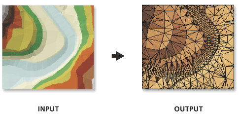
Exports triangle faces from a triangulated irregular network (TIN) dataset to a polygon feature class and provides slope, aspect, and optional attributes of hillshade and tag value for each triangle.
Illustration
 |
Usage
- Slope and aspect calculations are based on the plane of the triangle. Slope cannot be calculated properly if the linear unit of the TIN's coordinate system uses angular measures, like decimal degrees.
- XY and Z linear units should be in the same unit of measure in order for slope and hillshade calculations to provide accurate results. If the units differ but the TIN has its vertical and horizontal coordinate systems defined, an appropriate Z-factor is automatically determined. Otherwise, the Z Factor parameter can be used to explicitly define the conversion factor to be applied on the elevation values.
- Aspect values are expressed in degrees and assume that North is 0°. The values increase clockwise and are recorded in the Aspectfield. An aspect value of -1 is assigned for any flat triangle in the TIN.
- Slope can be returned in degrees or percent, and the field name that the values are recorded in depends on the selection made in theSlope Units parameter:
- PERCENT—Slope values will be stored in a field named Slope_Pct.
- DEGREE—Slope values will be stored in a field named Slope_Deg.
- Hillshade values reflect the localized relief that is produced from a light source that assumes the azimuth and vertical angle specified in the Hillshade parameter. 0° is assumed to be North for the azimuth, and the brightness value is expressed in between 0 to 255, where the lower the number, the darker the shade.
- Tag Value Field parameter will only be active if the TIN has tag values that were explicitly defined.


0 commentaires